

Deep learning-based spatio-temporal framework for opioid overdose monitoring in rural Alabama

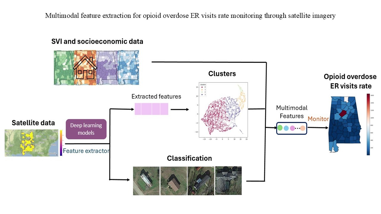
Timely and accurate monitoring of opioid overdose risks is critical for public health, particularly in underserved rural regions. Traditional surveillance systems often lack the spatial and temporal resolution needed to support proactive interventions. While socioeconomic indicators, such as the social vulnerability index and housing value, show moderate correlations with opioid-related outcomes, existing methods rarely incorporate high-resolution environmental data. Previous research relies largely on static census data and coarse geographic indicators, limiting its ability to detect localized risk patterns. Moreover, the connection between built-environment features and opioid overdose remains underexplored—especially in rural areas like Alabama’s Black Belt. To address this gap, we propose a multiscale spatio-temporal framework that integrates satellite imagery and machine learning to monitor opioid-related emergency room (ER) visit rates. We collected 201,967 housing images from Black Belt counties and classified them using computer vision models, including ResNet and external attention transformers. To overcome limitations in labeled data, we developed four unsupervised pipelines combining k-means clustering with autoencoders, masked autoencoders, VGG16, and household-image ratios. Our results show that unsupervised embeddings outperform supervised classification in capturing signals associated with ER visits. Descriptive features, such as roof type, road layout, and environmental openness, significantly inform predictions. Although Black Belt counties report lower absolute ER visit rates, they show faster year-over-year growth. Our study demonstrates the potential of combining satellite imagery with multimodal artificial intelligence to improve rural health surveillance and supports the development of scalable, interpretable monitoring tools for early intervention and policy planning.
- Weiner SG, Ibrahimi SE, Hendricks MA, et al. Factors associated with opioid overdose after an initial opioid prescription. JAMA Network Open. 2022;5(1):e2145691. doi: 10.1001/jamanetworkopen.2021.45691
- Florence C, Luo F, Rice K. The economic burden of opioid use disorder and fatal opioid overdose in the United States, 2017. Drug Alcohol Depend. 2020;218:108350. doi: 10.1016/j.drugalcdep.2020.108350
- Ibragimov U, Young AM, Cooper HLF. Understanding rural risk environments for drug-related harms: Progress, challenges, and steps forward. Int J Drug Policy. 2020;85:102926. doi: 10.1016/j.drugpo.2020.102926
- Drug Overdose Deaths in the U.S. Top 100,000 Annually. NCHS Pressroom. Available from: https://www.cdc.gov/ nchs/pressroom/releases/20211117.html [Last accessed on 2023 Sep 08].
- Alkhelaiwi M, Boulila W, Ahmad J, Koubaa A, Driss M. An efficient approach based on privacy-preserving deep learning for satellite image classification. Remote Sens. 2021;13(11):2221.doi: 10.3390/rs13112221
- Acharya A, Izquierdo AM, Gonçalves SF, et al. Exploring county-level spatio-temporal patterns in opioid overdose related emergency department visits. PLoS One. 2022;17(12):e0269509. doi: 10.1371/journal.pone.0269509
- Crawford ND, Haardöerfer R, Cooper H, et al. Characterizing the rural opioid use environment in Kentucky using Google Earth: Virtual audit. J Med Internet Res. 2019;21(10):e14923. doi: 10.2196/14923
- Jean N, Burke M, Xie M, Davis WM, Lobell DB, Ermon S. Combining satellite imagery and machine learning to predict poverty. Science. 2016;353(6301):790-794. doi: 10.1126/science.aaf7894
- Wu X, Cao S, Lee HY, Gong J. Let Every Voice Be Heard: Developing a Cost-Effective Community Sampling Frame in Rural Alabama to Combat COVID-19 (Poster). In: 2022 IEEE/ACM Conference on Connected Health: Applications, Systems and Engineering Technologies (CHASE). IEEE; 2022.
- Tumpa PP, Islam MS. Lightweight parallel convolutional neural network with SVM classifier for satellite imagery classification. IEEE Trans Artif Intell. 2024;5(11):5676-5688. doi: 10.1109/tai.2024.3423813
- Yeh C, Perez A, Driscoll A, et al. Using publicly available satellite imagery and deep learning to understand economic well-being in Africa. Nat Commun. 2020;11(1):2583. doi: 10.1038/s41467-020-16185-w
- Li Z, Jia Y, Liu H, Hou J. Learning from Sample Stability for Deep Clustering. In: Proceedings of the 42nd International Conference on Machine Learning. 2025:34904-34919.
- Jean N, Wang S, Samar A, Azzari G, Lobell D, Ermon S. Tile2Vec: Unsupervised representation learning for spatially distributed data. arXiv. Preprint posted online 2018. doi: 10.48550/arXiv.1805.02855
- Okaidat A, Melhem S, Alenezi H, Duwairi R. Using Convolutional Neural Networks on Satellite Images to Predict Poverty. In: 2021 12th International Conference on Information and Communication Systems (ICICS); 2021. p. 164-170. doi: 10.1109/icics52457.2021.9464598
- Shi J, Wu T, Qin AK, Lei Y, Jeon G. Self-guided autoencoders for unsupervised change detection in heterogeneous remote sensing images. IEEE Trans Artif Intell. 2024;5(6):2458-2471. doi: 10.1109/tai.2024.3357667
- Gong J, Wu X. Advancing Data Quality for Healthcare AI: Integrating Google Earth and Community Data in Opioid Crisis Mitigation. In: Proceedings of the ACM/IEEE International Conference on Connected Health: Applications, Systems and Engineering Technologies; 2025:329-334. doi: 10.1145/3721201.3725436
- Bianco S. Meta-XAI for explaining the explainer: Unveiling image features driving deep learning decisions. IEEE Trans Artif Intell. 2025;6(7):1859-1869. doi: 10.1109/tai.2025.3529397
- Wurm M, Stark T, Zhu XX, Weigand M, Taubenböck H. Semantic segmentation of slums in satellite images using transfer learning on fully convolutional neural networks. ISPRS J Photogram Remote Sens. 2019;150:59-69. doi: 10.1016/j.isprsjprs.2019.02.006
- Mak HWL. From COVID-19 Pandemic of Five Selected East Asian Cities to Assessment of Data Openness and Integration for Future City Development. Joint Lab on Future Cities (JLFC) Report No. 2. 2021. Available from: https://jlfc.hku.hk/ wp-content/uploads/2025/10/JLFC-Report-2_Final.pdf [Last accessed on 2025 Nov 12].
- Stokes EK, Pickens CM, Wilt G, Liu S, David F. County-level social vulnerability and nonfatal drug overdose emergency department visits and hospitalizations, January 2018-December 2020. Drug Alcohol Depend. 2023;247:109889. doi: 10.1016/j.drugalcdep.2023.109889
- Han S, Jeong Y, Lee K, In J. Environmental sustainability in health care: An empirical investigation of US hospitals. Bus Strategy Environ. 2024;33(6):6045-6065. doi: 10.1002/bse.3790
- Bedi C, Kansal A, Mukheibir P. A conceptual framework for the assessment of and the transition to liveable, sustainable and equitable cities. Environ Sci Policy. 2022;140:134-145. doi: 10.1016/j.envsci.2022.11.018
- Badanta B, Sierra AP, Fernández ST, et al. Advancing environmental sustainability in healthcare: Review on perspectives from health institutions. Environments. 2025;12(1):9. doi: 10.3390/environments12010009
- Chi Y, Mak H. From comparative and statistical assessments of liveability and health conditions of districts in hong kong towards future city development. Sustainability. 2021;13(16):8781. doi: 10.3390/su13168781
- Chichester K, Drawve G, Giménez-Santana A, et al. Pharmacies and features of the built environment associated with opioid overdose: A geospatial comparison of rural and urban regions in Alabama, USA. Int J Drug Policy. 2020;79:102736. doi: 10.1016/j.drugpo.2020.102736
- Lee HY, Wang K, Choi E, Gajos JM, Won CR. Opioid literacy among African Americans living in rural Alabama: Findings from a social determinants of health (SDH) framework. J Drug Issues. 2022;53(1):3-17. doi: 10.1177/00220426221093610
- Monnat SM, Peters DJ, Berg MT, Hochstetler A. Using census data to understand County-Level differences in overall drug mortality and opioid-related mortality by opioid type. Am J Public Health. 2019;109(8):1084-1091. doi: 10.2105/ajph.2019.305136
- Rigg KK, Monnat SM, Chavez MN. Opioid-related mortality in rural America: Geographic heterogeneity and intervention strategies. Int J Drug Policy. 2018;57:119-129. doi: 10.1016/j.drugpo.2018.04.011
- Mpofu E, Athanasou J, Craig A, Heasley S. Disability and vocational rehabilitation in rural and remote Australasia. In: Disability and Vocational Rehabilitation in Rural Settings: Challenges to Service Delivery. Berlin: Springer; 2017. p. 335-352. doi: 10.1007/978-3-319-64786-9_18
- Brodie ML. Understanding Data Science: An Emerging Discipline for Data Intensive Discovery. DAMDID/RCDL. 2015;238-245.
- Jenkins RA, Hagan H. What is a rural opioid risk and policy environment? Int J Drug Policy. 2019;85:102606. doi: 10.1016/j.drugpo.2019.11.014
- Flanagan BE, Gregory EW, Hallisey EJ, Heitgerd JL, Lewis B. A social vulnerability Index for disaster management. J Homeland Security Emerg Manag. 2011;8(1):4-6. doi: 10.2202/1547-7355.1792
- Client Challenge. Available from: https://www.scribd.com/ document/786906346/svi-poster-07032014-final [Last accessed on 2022 Jan 18].
- Gaynor TS, Wilson ME. Social vulnerability and equity: the disproportionate impact of COVID‐19. Public Administ Rev. 2020;80(5):832-838. doi: 10.1111/puar.13264
- Watmough GR, Marcinko CLJ, Sullivan C, et al. Socioecologically informed use of remote sensing data to predict rural household poverty. Proc Natl Acad Sci U S A. 2019;116(4):1213-1218. doi: 10.1073/pnas.1812969116
- Find a satellite image photo of your home. Available from: https://www.satsig.net/maps/satellite-photo-image-viewer. htm [Last accessed on 2022 Jan 10].
- Pritt M, Chern G. Satellite image classification with deep learning. In: 2017 IEEE Applied Imagery Pattern Recognition Workshop (AIPR); 2017. p. 1-7. doi: 10.1109/aipr.2017.8457969
- Rivera AJ, Pérez-Godoy MD, Elizondo D, Deka L, Del Jesus MJ. Analysis of clustering methods for crop type mapping using satellite imagery. Neurocomputing. 2022;492:91-106. doi: 10.1016/j.neucom.2022.04.002
- Arabmakki E, Kantardzic M, Sethi TS. Ensemble Classifier for Imbalanced Streaming Data Using Partial Labeling. In: 2016 IEEE 17th International Conference on Information Reuse and Integration (IRI). IEEE; 2016:257-260. doi: 10.1109/iri.2016.40
- Simonyan K, Zisserman A. Very Deep Convolutional Networks for Large-Scale Image Recognition. arXiv. Preprint posted online 2014. doi: 10.48550/arXiv.1409.1556
- Briggs M. SatDash: An Interactive Dashboard for Assessing Land Damage in Nigeria and Mali. In: Proceedings of the 4th ACM SIGCAS Conference on Computing and Sustainable Societies; 2021:100-114 doi: 10.1145/3460112.3471949