

Mapping chronic environmental pressure in Goa using machine learning and deep learning

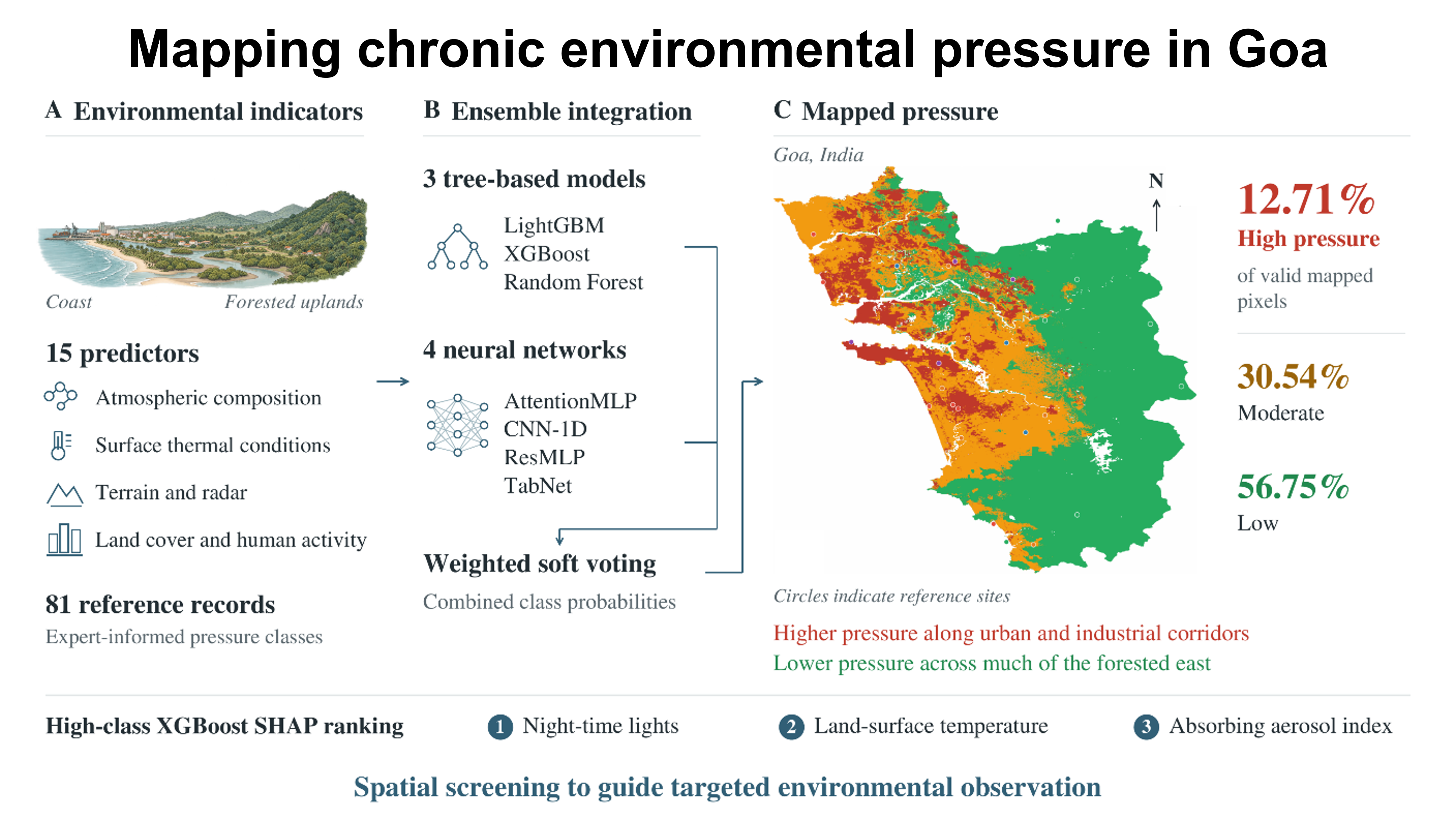
Coastal landscapes experience overlapping environmental pressures that require integrated spatial assessment. This study combines satellite and geospatial indicators to map chronic environmental pressure in Goa, India. Fifteen predictors represent atmospheric composition, terrain, land-surface conditions, land use, and human activity. Time-filtered products cover available observations within a nominal 2018–2023 period, alongside static and differently dated products. Of 89 expert-informed reference records, 81 supplied predictor information for three tree-based algorithms and four neural-network architectures. Their probabilities were combined into an environmental-pressure classification. Low-, moderate-, and high-classes accounted for 56.75%, 30.54%, and 12.71% of valid mapped pixels, respectively. Higher scores characterised urban and industrial corridors, whereas forested eastern areas generally recorded lower scores. Night-time lights had the largest contribution to the high-class extreme gradient boosting Shapley additive explanations. Model scores align with the expert-informed reference classes. The integrated maps provide a relative screening framework in selecting locations for further environmental observation.
- Intergovernmental Panel on Climate Change (IPCC). Climate Change 2021 – The Physical Science Basis: Working Group I Contribution to the Sixth Assessment Report of the Intergovernmental Panel on Climate Change. Cambridge, England: Cambridge University Press; 2021. doi: 10.1017/9781009157896
- Patel JB, Raval Z. The impacts of urbanization on ecological systems: a comprehensive study of the complex challenges arising from rapid urban growth. Res Rev J Indian Knowl Syst. 2024;1(1):1-10. doi: 10.31305/rrjiks.2024.v1.n1.001
- Rimal B, Baral H, Stork N, Paudyal K, Rijal S. Growing city and rapid land use transition: assessing multiple hazards and risks in the Pokhara Valley, Nepal. Land. 2015;4(4):957-978. doi: 10.3390/land4040957
- Dutta D, Srinivas VV, Bala G. Disparity in spatiotemporal variability and risk of compound coastal extremes between India's East-West coasts. NPJ Clim Atmos Sci. 2025;8(1):168. doi: 10.1038/s41612-025-01045-5
- Kundzewicz ZW, Kanae S, Seneviratne SI, et al. Flood risk and climate change: global and regional perspectives. Hydrol Sci J. 2014;59(1):1-28. doi: 10.1080/02626667.2013.857411
- Almar R, Ranasinghe R, Bergsma EWJ, et al. A global analysis of extreme coastal water levels with implications for potential coastal overtopping. Nat Commun. 2021;12(1):3775. doi: 10.1038/s41467-021-24008-9
- Balica SF, Wright NG, van der Meulen F. A flood vulnerability index for coastal cities and its use in assessing climate change impacts. Nat Hazards. 2012;64(1):73-105. doi: 10.1007/s11069-012-0234-1
- Cazenave A, Cozannet GL. Sea level rise and its coastal impacts. Earths Future. 2014;2(2):15-34. doi: 10.1002/2013EF000188
- Wang Q, Hou J, Li J, Guo H. A multihazard assessment framework integrating single and coupled scenario analysis for droughts, floods, and landslides. Geomatics Nat Hazards Risk. 2026;17(1):2620070. doi: 10.1080/19475705.2026.2620070
- Wenzel T, van Westen C, Sunil M, et al. Towards a practical multi-hazard interrelation classification: implications for assessing their impacts. Nat Hazards. 2026;122(2):82. doi: 10.1007/s11069-025-07901-0
- Marlier ME, Connolly R, Ma Y, Jerrett M, Benmarhnia T. Compound climate exposures and public health: a synthesis of research and future directions. Annu Rev Public Health. 2026;47(1):305-323. doi: 10.1146/annurev-publhealth-090924-113926
- Jäger WS, de Ruiter MC, Tiggeloven T, Ward PJ. What can we learn about multi-hazard impacts from global disaster records? Nat Hazards Earth Syst Sci. 2025;25(8):2751-2769. doi: 10.5194/nhess-25-2751-2025
- Hafezi M, Sahin O, Stewart R, Mackey B. Creating a novel multi-layered integrative climate change adaptation planning approach using a systematic literature review. Sustainability (Basel). 2018;10(11):4100. doi: 10.3390/su10114100
- Nghia Nguyen H, Quan Le Q, Dung Nguyen V, et al. Assessment of coastal inundation triggered by multiple drivers in Ca Mau Peninsula, Vietnam. Nat Hazards Earth Syst Sci. 2025;25(10):4227-4246. doi: 10.5194/nhess-25-4227-2025
- Barnard PL, Erikson LH, Foxgrover AC, et al. Dynamic flood modeling essential to assess the coastal impacts of climate change. Sci Rep. 2019;9(1):4309. doi: 10.1038/s41598-019-40742-z
- Sun H, Zhang X, Ruan X, Jiang H, Shou W. Mapping compound flooding risks for urban resilience in coastal zones: a comprehensive methodological review. Remote Sens (Basel). 2024;16(2):350. doi: 10.3390/rs16020350
- Akosah S, Gratchev I. Systematic review of post-wildfire landslides. GeoHazards. 2025;6(1):12. doi: 10.3390/geohazards6010012
- Moftakhari H, AghaKouchak A. Increasing exposure of energy infrastructure to compound hazards: cascading wildfires and extreme rainfall. Environ Res Lett. 2019;14(10):104018. doi: 10.1088/1748-9326/ab41a6
- Razavi-Termeh SV, Sadeghi-Niaraki A, Ali F, Pradhan B, Choi SM. Optimizing ensemble learning for satellite-based multi-hazard monitoring and susceptibility assessment of landslides, land subsidence, floods, and wildfires. Sci Rep. 2025;15(1):30968. doi: 10.1038/s41598-025-15381-2
- Arshad S, Ahmad SR, Abbas S, Asharf A, Siddiqui NA, Islam Zu. Quantifying the contribution of diminishing green spaces and urban sprawl to urban heat island effect in a rapidly urbanizing metropolitan city of Pakistan. Land Use Policy. 2022;113:105874. doi: 10.1016/j.landusepol.2021.105874
- Rahaman ZA, Kafy AA, Saha M, et al. Assessing the impacts of vegetation cover loss on surface temperature, urban heat island and carbon emission in Penang city, Malaysia. Build Environ. 2022;222:109335. doi: 10.1016/j.buildenv.2022.109335
- Grigoraș G, Urițescu B. Land use/land cover changes dynamics and their effects on surface urban heat island in Bucharest, Romania. Int J Appl Earth Obs Geoinf. 2019;80:115-126. doi: 10.1016/j.jag.2019.03.009
- He JF, Liu JY, Zhuang DF, Zhang W, Liu ML. Assessing the effect of land use/land cover change on the change of urban heat island intensity. Theor Appl Climatol. 2007;90(3-4):217-226. doi: 10.1007/s00704-006-0273-1
- Afandi GE, Moustafa A, Ibrahim S, Irfan M. An in-depth analysis of approaches for forecasting extreme rainfall events leveraging artificial intelligence, machine learning, and deep learning techniques. Earth Syst Environ. 2026;10(4):5073-5104. doi: 10.1007/s41748-025-00813-w
- Pugliese Viloria AdJ, Folini A, Carrion D, Brovelli MA. Hazard susceptibility mapping with machine and deep learning: a literature review. Remote Sens (Basel). 2024;16(18):3374. doi: 10.3390/rs16183374
- Kumar R, Bhanu M, Mendes-Moreira J, Chandra J. Spatio-temporal predictive modeling techniques for different domains: a survey. ACM Comput Surv. 2025;57(2):1-42. doi: 10.1145/3696661
- Li W, Hsu CY. GeoAI for large-scale image analysis and machine vision: recent progress of artificial intelligence in geography. ISPRS Int J Geoinf. 2022;11(7):385. doi: 10.3390/ijgi11070385
- Feng L, Zhang M, Mao Y, et al. Convolutional neural network-based deep learning for landslide susceptibility mapping in the Bakhtegan watershed. Sci Rep. 2025;15(1):13250. doi: 10.1038/s41598-025-96748-3
- Amato F, Guignard F, Robert S, Kanevski M. A novel framework for spatio-temporal prediction of environmental data using deep learning. Sci Rep. 2020;10(1):22243. doi: 10.1038/s41598-020-79148-7
- Lynda D, Logeswari G, Tamilarasi K, Rakesh S. Hybrid Bayesian deep learning model for predicting urban heat island intensity in African cities. Sci Rep. 2025;15(1):31280. doi: 10.1038/s41598-025-13492-4
- Das A, Rad P. Opportunities and challenges in explainable artificial intelligence (XAI): a survey. arXiv. Preprint posted online 2020. Updated June 23, 2020. Accessed September 21, 2026. doi: 10.48550/arXiv.2006.11371
- Geng H, Wang W, Liu J, Benson D. Landslide susceptibility modeling based on SHAP interpretability and ensemble learning: a case study in Fuyuan County, Southwest China. Front Earth Sci. 2025;13:1731872. doi: 10.3389/feart.2025.1731872
- Zhang J, Ma X, Zhang J, et al. Insights into geospatial heterogeneity of landslide susceptibility based on the SHAP-XGBoost model. J Environ Manage. 2023;332:117357. doi: 10.1016/j.jenvman.2023.117357
- Zhu H, Zhang X, Wei G, et al. A method for better mapping of susceptibility to thaw hazards in data-scarce cold regions. Remote Sens Environ. 2026;337:115338. doi: 10.1016/j.rse.2026.115338
- Gomez Rave DV, Scolobig A, del Jesus M. Review article: rethinking preparedness for coastal compound flooding: insights from a systematic review. Nat Hazards Earth Syst Sci. 2025;25(10):3977-4002. doi: 10.5194/nhess-25-3977-2025
- Haer T, de Ruiter M. A multi-hazard perspective on equitable adaptation and how to assess it. PLOS Clim. 2024;3(12):e0000521. doi: 10.1371/journal.pclm.0000521
- Antofie TE, Luoni S, Tilloy A, et al. Spatial identification of regions exposed to multi-hazards at the pan-European level. Nat Hazards Earth Syst Sci. 2025;25(1):287-304. doi: 10.5194/nhess-25-287-2025
- Hochrainer-Stigler S, Šakić Trogrlić R, Reiter K, et al. Toward a framework for systemic multi-hazard and multi-risk assessment and management. iScience. 2023;26(5):106736. doi: 10.1016/j.isci.2023.106736
- Nalmpant-Sarikaki DM, Theocharis AI, Koukouzas NC, Zevgolis IE. A framework for effective multi-hazard risk assessment in post-mining areas. Safety (Basel). 2025;11(1):18. doi: 10.3390/safety11010018
- Damalas A, Mettas C, Evagorou E, et al. Development and implementation of a DECATASTROPHIZE platform and tool for the management of disasters or multiple hazards. Int J Disaster Risk Reduct. 2018;31:589-601. doi: 10.1016/j.ijdrr.2018.05.011
- Gacu J, Kantoush S, Candelario R, et al. Integrated multi-hazard risk assessment under compound disasters using analytical hierarchy process (AHP). Heliyon. 2025;11(11):e43173. doi: 10.1016/j.heliyon.2025.e43173
- Houssein EH, Dirar M, Ali AA, Mohamed WM, Hamed K. Advances in artificial intelligence for climate science methods applications and evaluation challenges. Discov Artif Intell. 2026;6(1):441. doi: 10.1007/s44163-026-01262-8
- Llavina Pascual X, Pablos Cascallar M, Planell i Calle M, Puigdollers Rodés E, Solé Carbonell C, Vila i Casau A. Iron Mining in Goa (India): An Interdisciplinary Study [bachelor's thesis]. Barcelona, Spain: Universitat Autònoma de Barcelona; 2013. Accessed September 21, 2026. https://ddd.uab.cat/pub/trerecpro/2013/hdl_2072_223218/PFC_IronMiningGoa.pdf
- Nigam R, Luis AJ, Gagnon AS, Vaz E, Damásio B, Kotha M. Assessing coastal vulnerability at the village level using a robust framework, the example of Canacona in South Goa, India. iScience. 2024;27(4):109129. doi: 10.1016/j.isci.2024.109129
- Saha M, Naik A, Desai A, et al. Microplastics in seafood as an emerging threat to marine environment: a case study in Goa, west coast of India. Chemosphere. 2021;270:129359. doi: 10.1016/j.chemosphere.2020.129359
- Department of Information and Publicity. About Goa. Government of Goa. Accessed September 21, 2026. https://dip.goa.gov.in/about-goa/
- Gorelick N, Hancher M, Dixon M, Ilyushchenko S, Thau D, Moore R. Google Earth Engine: planetary-scale geospatial analysis for everyone. Remote Sens Environ. 2017;202:18-27. doi: 10.1016/j.rse.2017.06.031
- TROPOMI. Aerosol Index (L2__AER_AI) and Carbon Monoxide (L2__CO____) product documentation. Data Products. Accessed September 21, 2026. https://www.tropomi.eu/data-products
- ESA WorldCover Consortium. WorldCover 10 m 2020 v100. Earth Engine Data Catalog. Accessed September 21, 2026. https://developers.google.com/earth-engine/datasets/catalog/ESA_WorldCover_v100
- WorldPop. WorldPop Global Project Population Data (R2025A): estimated residential population per 100x100m grid square. Earth Engine Data Catalog. Accessed September 21, 2026. https://developers.google.com/earth-engine/datasets/catalog/WorldPop_GP_100m_R2025A_v1_pop
- US Geological Survey. Landsat 8 Level 2 Collection 2 Tier 1. Earth Engine Data Catalog. Accessed September 21, 2026. https://developers.google.com/earth-engine/datasets/catalog/LANDSAT_LC08_C02_T1_L2
- Yamazaki D, Ikeshima D, Sosa J, Bates PD, Allen GH, Pavelsky TM. MERIT Hydro: a high-resolution global hydrography map based on latest topography dataset. Water Resour Res. 2019;55(6):5053-5073. doi: 10.1029/2019WR024873
- Ploton P, Mortier F, Réjou-Méchain M, et al. Spatial validation reveals poor predictive performance of large-scale ecological mapping models. Nat Commun. 2020;11(1):4540. doi: 10.1038/s41467-020-18321-y
- Wang M, Beelen R, Eeftens M, Meliefste K, Hoek G, Brunekreef B. Systematic evaluation of land use regression models for NO2. Environ Sci Technol. 2012;46(8):4481-4489. doi: 10.1021/es204183v
- Lundberg SM, Lee SI. A unified approach to interpreting model predictions. In: von Luxburg U, Guyon I, Bengio S, Wallach H, Fergus R, eds. Proceedings of the 31st International Conference on Neural Information Processing Systems (NIPS'17); December 4-9, 2017; Long Beach, CA. Red Hook, NY: Curran Associates Inc.; 2017:4768-4777. doi: 10.5555/3295222.3295230
- Lundberg SM, Erion G, Chen H, et al. From local explanations to global understanding with explainable AI for trees. Nat Mach Intell. 2020;2(1):56-67. doi: 10.1038/s42256-019-0138-9
- Chawla NV, Bowyer KW, Hall LO, Kegelmeyer WP. SMOTE: synthetic minority over-sampling technique. J Artif Intell Res. 2002;16:321-357. doi: 10.1613/jair.953
- Kaufman S, Rosset S, Perlich C, Stitelman O. Leakage in data mining: formulation, detection, and avoidance. ACM Trans Knowl Discov Data. 2012;6(4):15:1-15:21. doi: 10.1145/2382577.2382579
- Kapoor S, Narayanan A. Leakage and the reproducibility crisis in machine-learning-based science. Patterns. 2023;4(9):100804. doi: 10.1016/j.patter.2023.100804
- Han H, Wang WY, Mao BH. Borderline-SMOTE: a new over-sampling method in imbalanced data sets learning. In: Huang DS, Zhang XP, Huang GB, eds. Advances in Intelligent Computing (Lecture Notes in Computer Science). Vol 3644. Berlin, Germany: Springer; 2005:878-887. doi: 10.1007/11538059_91
- Ke G, Meng Q, Finley T, et al. LightGBM: a highly efficient gradient boosting decision tree. In: Guyon I, von Luxburg U, Bengio S, Wallach H, Fergus R, Vishwanathan S, Garnett R, eds. Advances in Neural Information Processing Systems 30. Red Hook, NY: Neural Information Processing Systems Foundation, Inc.; 2017:3146-3154.
- Chen T, Guestrin C. XGBoost: a scalable tree boosting system. In: KDD '16: Proceedings of the 22nd ACM SIGKDD International Conference on Knowledge Discovery and Data Mining; August 13-17, 2016; San Francisco, CA. New York, NY: Association for Computing Machinery; 2016:785-794. doi: 10.1145/2939672.2939785
- Breiman L. Random forests. Mach Learn. 2001;45(1):5-32. doi: 10.1023/A:1010933404324
- Arik SÖ, Pfister T. TabNet: attentive interpretable tabular learning. Proc AAAI Conf Artif Intell. 2021;35(8):6679-6687. doi: 10.1609/aaai.v35i8.16826
- Le Rest K, Pinaud D, Monestiez P, Chadoeuf J, Bretagnolle V. Spatial leave-one-out cross-validation for variable selection in the presence of spatial autocorrelation. Glob Ecol Biogeogr. 2014;23(7):811-820. doi: 10.1111/geb.12161
- Roberts DR, Bahn V, Ciuti S, et al. Cross-validation strategies for data with temporal, spatial, hierarchical, or phylogenetic structure. Ecography. 2017;40(8):913-929. doi: 10.1111/ecog.02881
- Powers DMW. Evaluation: from precision, recall and F-measure to ROC, informedness, markedness & correlation. J Mach Learn Technol. 2011;2(1):37-63.
- Brodersen KH, Ong CS, Stephan KE, Buhmann JM. The balanced accuracy and its posterior distribution. In: Proceedings of the 20th International Conference on Pattern Recognition; August 23-26, 2010; Istanbul, Turkey. Piscataway, NJ: IEEE Computer Society; 2010:3121-3124. doi: 10.1109/ICPR.2010.764
- Gorodkin J. Comparing two K-category assignments by a K-category correlation coefficient. Comput Biol Chem. 2004;28(5-6):367-374. doi: 10.1016/j.compbiolchem.2004.09.006
- Shannon CE. A mathematical theory of communication. Bell Syst Tech J. 1948;27(3):379-423. doi: 10.1002/j.1538-7305.1948.tb01338.x
- Tornetta GN. Entropy methods for the confidence assessment of probabilistic classification models. arXiv. Preprint posted online March 28, 2021. Accessed September 21, 2026. doi: 10.48550/arXiv.2103.15157
- Cedergreen N. Quantifying synergy: a systematic review of mixture toxicity studies within environmental toxicology. PLoS One. 2014;9(5):e96580. doi: 10.1371/journal.pone.0096580
- Gill JC, Malamud BD. Reviewing and visualizing the interactions of natural hazards. Rev Geophys. 2014;52(4):680-722. doi: 10.1002/2013RG000445
- Hollmann N, Müller S, Purucker L, et al. Accurate predictions on small data with a tabular foundation model. Nature. 2025;637(8045):319-326. doi: 10.1038/s41586-024-08328-6
- Si JYH, Cheng WY, Cooper M, Krishnan R. InterpreTabNet: distilling predictive signals from tabular data by salient feature interpretation. Proc Mach Learn Res. 2024;235:45353-45405. Accessed September 21, 2026. https://proceedings.mlr.press/v235/si24a.html
- Grinsztajn L, Oyallon E, Varoquaux G. Why do tree-based models still outperform deep learning on tabular data? arXiv. Preprint posted online July 18, 2022. Accessed September 21, 2026. doi: 10.48550/arXiv.2207.08815
- Bennett MM, Smith LC. Advances in using multitemporal night-time lights satellite imagery to detect, estimate, and monitor socioeconomic dynamics. Remote Sens Environ. 2017;192:176-197. doi: 10.1016/j.rse.2017.01.005
- Bhattarai D, Lucieer A, Lovell H, Aryal J. Remote sensing of night-time lights and electricity consumption: a systematic literature review and meta-analysis. Geogr Compass. 2023;17(4):e12684. doi: 10.1111/gec3.12684
- Mellander C, Lobo J, Stolarick K, Matheson Z. Night-time light data: a good proxy measure for economic activity? PLoS One. 2015;10(10):e0139779. doi: 10.1371/journal.pone.0139779
- Zheng Q, Seto KC, Zhou Y, You S, Weng Q. Nighttime light remote sensing for urban applications: progress, challenges, and prospects. ISPRS J Photogramm Remote Sens. 2023;202:125-141. doi: 10.1016/j.isprsjprs.2023.05.028
- Gill JC, Malamud BD. Hazard interactions and interaction networks (cascades) within multi-hazard methodologies. Earth Syst Dyn. 2016;7(3):659-679. doi: 10.5194/esd-7-659-2016
- White CJ, Adnan MSG, Arosio M, et al. Review article: towards multi-hazard and multi-risk indicators—a review and recommendations for development and implementation. Nat Hazards Earth Syst Sci. 2025;25(11):4263-4281. doi: 10.5194/nhess-25-4263-2025