

Recognition of ecological security patterns based on the geographical detector model

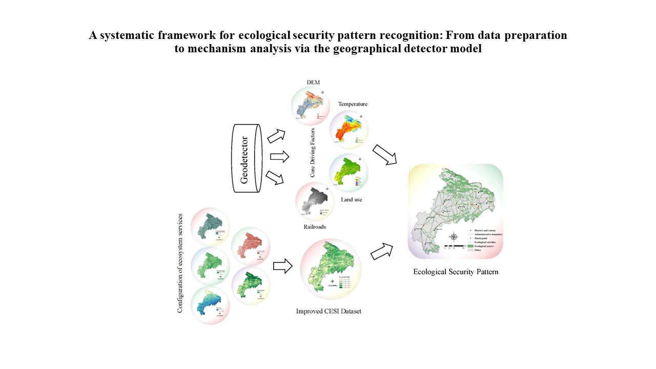
Constructing a regional ecological security pattern (ESP) is essential for maintaining ecosystem health and enhancing ecosystem service functions. However, most existing ESP studies focus only on future scenarios and lack an integrated analysis of historical and future conditions. The selection of resistance factors usually depends on expert experience, which is often constrained by insufficient basic data. This study takes northeastern Chongqing as the study area and innovatively combines the geographical detector model with the patch-level land use simulation model, morphological spatial pattern analysis model, and circuit theory to establish a cross-temporal ESP from 2000 to 2030, integrating historical retrospective analysis and future scenario prediction. The geographical detector model was used to quantitatively identify the core driving factors of the comprehensive ecosystem service index (CESI), avoiding subjective factor selection and providing a scientific method for ESP construction in data-scarce regions. Coupling multi-scenario land-use simulation with ecosystem service assessment enables dynamic identification of ecological sources and objective construction of resistance surfaces, filling the research gap of integrated past–future ESP analysis. The results show that changes in forest land from 2000 to 2030 are concentrated in the central and northeastern parts, reflecting the trade-off between ecological protection and urbanization in the Three Gorges Reservoir Area. Temperature, digital elevation model, land use, and railroads are the dominant drivers of CESI, revealing the combined effects of natural and human activities. The northeast has complex ecological corridors and pinch points with high connectivity, while the southwest suffers from serious ecosystem fragmentation. This study provides a reproducible technical framework for ESP research in ecologically sensitive areas with limited data.
- Wen J, Hou K. Research on the progress of regional ecological security evaluation and optimization of its common limitations. Ecol Indic. 2021;127:107797.doi: 10.1016/j.ecolind.2021.107797
- Ke X, Wang X, Guo H, Yang C, Zhou Q, Mougharbel A. Urban ecological security evaluation and spatial correlation research-based on data analysis of 16 cities in Hubei Province of China. J Clean Prod. 2021;311:127613. doi: 10.1016/j.jclepro.2021.127613
- Shi K, Chen Y, Li L, Huang C. Spatiotemporal variations of urban CO2 emissions in China: A multiscale perspective. Appl Energy. 2018;211:218-229. doi: 10.1016/j.apenergy.2017.11.042
- Xia C, Dong Z, Wu P, et al. How urban land-use intensity affected CO2 emissions at the county level: Influence and prediction. Ecol Indic. 2022;145:109601. doi: 10.1016/j.ecolind.2022.109601
- Wei W, Li Y, Ma L, et al. Carbon emission change based on land use in Gansu Province. Environ Monit Assess. 2024;196(3):311. doi: 10.1007/s10661-024-12484-7
- Wei Q, Halike A, Yao K, Chen L, Balati M. Construction and optimization of ecological security pattern in Ebinur Lake Basin based on MSPA-MCR models. Ecol Indic. 2022;138:108857. doi: 10.1016/j.ecolind.2022.108857
- Tian H, Wang H, Lyu X, et al. Construction and optimization of ecological security patterns in Dryland watersheds considering ecosystem services flows. Ecol Indic. 2024;159:111664. doi: 10.1016/j.ecolind.2024.111664
- Gou M, Li L, Ouyang S, et al. Integrating ecosystem service trade-offs and rocky desertification into ecological security pattern construction in the Daning river basin of southwest China. Ecol Indic. 2022;138:108845. doi: 10.1016/j.ecolind.2022.108845
- Zhao Y, He L, Bai W, He Z, Luo F, Wang Z. Prediction of ecological security patterns based on urban expansion: A case study of Chengdu. Ecol Indic. 2024;158:111467. doi: 10.1016/j.ecolind.2023.111467
- Wang N, Zhao Y. Construction of an ecological security pattern in Jiangnan water network area based on an integrated Approach: A case study of Gaochun, Nanjing. Ecol Indic. 2024;158:111314. doi: 10.1016/j.ecolind.2023.111314
- Chen J, Wang S, Zou Y. Construction of an ecological security pattern based on ecosystem sensitivity and the importance of ecological services: A case study of the Guanzhong Plain urban agglomeration, China. Ecol Indic. 2022;136:108688. doi: 10.1016/j.ecolind.2022.108688
- Sun J, Li YP, Gao PP, Xia BC. A Mamdani fuzzy inference approach for assessing ecological security in the Pearl River Delta urban agglomeration, China. Ecol Indic. 2018;94:386- 396. doi: 10.1016/j.ecolind.2018.07.011
- Ran Y, Lei D, Li J, Gao L, Mo J, Liu X. Identification of crucial areas of territorial ecological restoration based on ecological security pattern: A case study of the central Yunnan urban agglomeration, China. Ecol Indic. 2022;143:109318. doi: 10.1016/j.ecolind.2022.109318
- Peng J, Pan Y, Liu Y, Zhao H, Wang Y. Linking ecological degradation risk to identify ecological security patterns in a rapidly urbanizing landscape. Habitat Int. 2018;71:110-124. doi: 10.1016/j.habitatint.2017.11.010
- Pan J, Liang J, Zhao C. Identification and optimization of ecological security pattern in arid inland basin based on ordered weighted average and ant colony algorithm: A case study of Shule River basin, NW China. Ecol Indic. 2023;154:110588. doi: 10.1016/j.ecolind.2023.110588
- Vergnes A, Kerbiriou C, Clergeau P. Ecological corridors also operate in an urban matrix: A test case with garden shrews. Urban Ecosyst. 2013;16(3):511-525. doi: 10.1007/s11252-013-0289-0
- Wei L, Zhou L, Sun D, Yuan B, Hu F. Evaluating the impact of urban expansion on the habitat quality and constructing ecological security patterns: A case study of Jiziwan in the Yellow River Basin, China. Ecol Indic. 2022;145:109544. doi: 10.1016/j.ecolind.2022.109544
- Shi F, Liu S, Sun Y, et al. Ecological network construction of the heterogeneous agro-pastoral areas in the upper Yellow River basin. Agric Ecosyst Environ. 2020;302:107069. doi: 10.1016/j.agee.2020.107069
- Qian W, Zhao Y, Li X. Construction of ecological security pattern in coastal urban areas: A case study in Qingdao, China. Ecol Indic. 2023;154:110754. doi: 10.1016/j.ecolind.2023.110754
- Xue F, Yang Y, Hu Yn. Integrating supply and benefits of ecosystem services into ecological security pattern: A spatial flow perspective. Ecol Indic. 2024;166:112455. doi: 10.1016/j.ecolind.2024.112455
- Huang J, Hu Y, Zheng F. Research on recognition and protection of ecological security patterns based on circuit theory: a case study of Jinan City. Environ Sci Pollut Res. 2020;27(11):12414-12427. doi: 10.1007/s11356-020-07764-x
- Luo J, Fu H. Construct the future wetland ecological security pattern with multi-scenario simulation. Ecol Indic. 2023;153:110473. doi: 10.1016/j.ecolind.2023.110473
- Huang X, Wang H, Shan L, Xiao F. Constructing and optimizing urban ecological network in the context of rapid urbanization for improving landscape connectivity. Ecol Indic. 2021;132:108319. doi: 10.1016/j.ecolind.2021.108319
- Peng J, Yang Y, Liu Y, et al. Linking ecosystem services and circuit theory to identify ecological security patterns. Sci Total Environ. 2018;644:781-790. doi: 10.1016/j.scitotenv.2018.06.292
- Dickson BG, Albano CM, Anantharaman R, et al. Circuit‐theory applications to connectivity science and conservation. Conserv Biol. 2018;33(2):239-249. doi: 10.1111/cobi.13230
- Zhou G, Huan Y, Wang L, et al. Linking ecosystem services and circuit theory to identify priority conservation and restoration areas from an ecological network perspective. Sci Total Environ. 2023;873:162261. doi: 10.1016/j.scitotenv.2023.162261
- Zhou G, Huan Y, Wang L, et al. Constructing a multi-leveled ecological security pattern for improving ecosystem connectivity in the Asian water Tower region. Ecol Indic. 2023;154:110597. doi: 10.1016/j.ecolind.2023.110597
- Wei M, Huang T. Multi-scale transformation and evolutionary factors of ecological security patterns in the Yangtze River Economic Belt. J Environ Manage. 2025;390:126308. doi: 10.1016/j.jenvman.2025.126308
- Du P, Xia J, Du Q, Luo Y, Tan K. Evaluation of the spatio-temporal pattern of urban ecological security using remote sensing and GIS. Int J Remote Sens. 2013;34(3):848-863. doi: 10.1080/01431161.2012.714503
- Wei W, Zhang X, Zhou L, Xie B, Zhou J, Li C. How does spatiotemporal variations and impact factors in CO2 emissions differ across cities in China? Investigation on grid scale and geographic detection method. J Clean Prod. 2021;321:128933. doi: 10.1016/j.jclepro.2021.128933
- Ding M, Liu W, Xiao L, et al. Construction and optimization strategy of ecological security pattern in a rapidly urbanizing region: A case study in central-south China. Ecol Indic. 2022;136:108604. doi: 10.1016/j.ecolind.2022.108604
- Liu X, Su Y, Li Z, Zhang S. Constructing ecological security patterns based on ecosystem services trade-offs and ecological sensitivity: A case study of Shenzhen metropolitan area, China. Ecol Indic. 2023;154:110626. doi: 10.1016/j.ecolind.2023.110626
- Pan N, Du Q, Guan Q, Tan Z, Sun Y, Wang Q. Ecological security assessment and pattern construction in arid and semi-arid areas: A case study of the Hexi Region, NW China. Ecol Indic. 2022;138:108797. doi: 10.1016/j.ecolind.2022.108797
- Xu ZP, Li YP, Huang GH, Wang SG, Liu YR. A multi-scenario ensemble streamflow forecast method for Amu Darya River Basin under considering climate and land-use changes. J Hydrol. 2021;598:126276. doi: 10.1016/j.jhydrol.2021.126276
- Wang Q, Guan Q, Sun Y, et al. Simulation of future land use/cover change (LUCC) in typical watersheds of arid regions under multiple scenarios. J Environ Manage. 2023;335:117543. doi: 10.1016/j.jenvman.2023.117543
- Xiao Y, Huang M, Xie G, Zhen L. Evaluating the impacts of land use change on ecosystem service values under multiple scenarios in the Hunshandake region of China. Sci Total Environ. 2022;850:158067. doi: 10.1016/j.scitotenv.2022.158067
- Wang Y, Li M, Jin G. Exploring the optimization of spatial patterns for carbon sequestration services based on multi-scenario land use/cover changes in the changchun-Jilin- Tumen region, China. J Clean Prod. 2024;438:140788. doi: 10.1016/j.jclepro.2024.140788
- Gao L, Tao F, Liu R, Wang Z, Leng H, Zhou T. Multi-scenario simulation and ecological risk analysis of land use based on the PLUS model: A case study of Nanjing. Sustain Cities Soc. 2022;85:104055. doi: 10.1016/j.scs.2022.104055
- Li W, Wang Y, Xie S, Cheng X. Coupling coordination analysis and spatiotemporal heterogeneity between urbanization and ecosystem health in Chongqing municipality, China. Sci Total Environ. 2021;791:148311. doi: 10.1016/j.scitotenv.2021.148311
- Li H, Shi D. Spatio-temporal variation in soil erosion on sloping farmland based on the integrated valuation of ecosystem services and trade-offs model: A case study of Chongqing, southwest China. Catena. 2024;236:107693. doi: 10.1016/j.catena.2023.107693
- Liu C, Wang C, Li Y, Wang Y. Spatiotemporal differentiation and geographic detection mechanism of ecological security in Chongqing, China. Glob Ecol Conserv. 2022;35:e02072. doi: 10.1016/j.gecco.2022.e02072
- Wu L, Fan F. Assessment of ecosystem services in new perspective: A comprehensive ecosystem service index (CESI) as a proxy to integrate multiple ecosystem services. Ecol Indic. 2022;138:108800. doi: 10.1016/j.ecolind.2022.108800
- Huang X, Liu J, Peng S, Huang B. The impact of multi-scenario land use change on the water conservation in central Yunnan urban agglomeration, China. Ecol Indic. 2023;147:109922. doi: 10.1016/j.ecolind.2023.109922
- Jiang L, Wang Z, Zuo Q, Du H. Simulating the impact of land use change on ecosystem services in agricultural production areas with multiple scenarios considering ecosystem service richness. J Clean Prod. 2023;397:136485. doi: 10.1016/j.jclepro.2023.136485
- Li P, Chen J, Li Y, Wu W. Using the InVEST-PLUS Model to Predict and Analyze the Pattern of Ecosystem Carbon storage in Liaoning Province, China. Remote Sens. 2023;15(16):4050. doi: 10.3390/rs15164050
- Kubiszewski I, Muthee K, Rifaee Rasheed A, et al. The costs of increasing precision for ecosystem services valuation studies. Ecol Indic. 2022;135:108551. doi: 10.1016/j.ecolind.2022.108551
- Zhang Y, Zhang L, Wang J, Dong G, Wei Y. Quantitative analysis of NDVI driving factors based on the geographical detector model in the Chengdu-Chongqing region, China. Ecol Indic. 2023;155:110978. doi: 10.1016/j.ecolind.2023.110978
- Li M, Abuduwaili J, Liu W, Feng S, Saparov G, Ma L. Application of geographical detector and geographically weighted regression for assessing landscape ecological risk in the Irtysh River Basin, Central Asia. Ecol Indic. 2024;158:111540. doi: 10.1016/j.ecolind.2023.111540
- Wu W, Zhang J, Sun Z, et al. Attribution analysis of land degradation in Hainan Island based on geographical detector. Ecol Indic. 2022;141:109119. doi: 10.1016/j.ecolind.2022.109119
- Zhang T, Chen W, Sheng Z, Wang P, Guan F. Ecological network construction and identification of important elements based on morphological spatial pattern analysis and circuit theory in Pingxiang City. J Nat Conserv. 2025;86:126902. doi: 10.1016/j.jnc.2025.126902
51. Rova S, Stocco A, Pranovi F. Sustainability threshold for multiple ecosystem services in the Venice lagoon, Italy. Ecosyst Serv. 2023;64:101568. doi: 10.1016/j.ecoser.2023.101568