

Evaluating the hydraulic performance and sustainability of the Simike–Nzovwe roadside drainage system in Mbeya City, Tanzania, using the hydrologic engineering centre’s river analysis system modelling

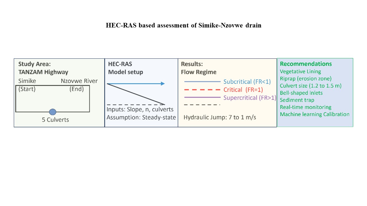
This study addresses the hydraulic inefficiencies and maintenance challenges associated with the roadside drainage system along a 1.85 km stretch of the TANZAM Highway between Simike and the Nzovwe River, which includes five circular culverts. The objective was to evaluate the system’s hydraulic performance under rainfall events using the Hydrologic Engineering Centre’s River Analysis System (HEC-RAS) one-dimensional hydraulic model. Specifically, the study focused on analyzing flow regimes, specific energy transitions, and sediment transport dynamics to identify critical points of inefficiency. The methodology involved simulating steady flow conditions, assessing the influence of channel and culvert geometry, and performing a sensitivity analysis on key hydraulic parameters, including Manning’s roughness coefficient, channel slope, and culvert dimensions. The model results revealed that subcritical flow conditions (Froude number, Fr <1) upstream of culverts lead to sediment accumulation, while steeper channel sections with supercritical flow (Fr >1) pose erosion risks. Pronounced hydraulic jumps were observed near culvert outlets, resulting in significant turbulence, abrupt energy dissipation, and localized erosion. Flow velocities decreased sharply from over 7 m/s to below 1 m/s across these transition zones. This study provides an integrated evaluation of hydraulic and sediment transport interactions in a real-world drainage system using HEC-RAS, supported by targeted design optimization strategies. Key recommendations include modifying side slope geometry, increasing longitudinal gradients, and enlarging culvert dimensions to enhance flow capacity and reduce sediment deposition. In addition, the application of riprap in high-velocity zones, vegetative lining in low-velocity areas, and the inclusion of sediment traps are proposed to control erosion and minimize maintenance.
- Rogers M, Enright B. Highway Engineering. Hoboken: John Wiley and Sons; 2023.
- Hancock MW, Wright B. A Policy on Geometric Design of Highways and Streets. American Association of State Highway and Transportation Officials. Washington, DC: USA; 2013. p. 20.
- Huang YH. Pavement Analysis and Design. NJ: Pearson/ Prentice Hall Upper Saddle River; 2004.
- Afolayan A, Abiola Samson O, Easa S, Alayaki FM, Folorunso O, Giunta M. Reliability-based analysis of highway geometric elements: A systematic review. Cogent Eng. 2022;9(1):2004672. doi: 10.1080/23311916.2021.2004672
- Traffic C. Manual on Uniform Traffic Control Devices. Washington, D.C: US Department of Transportation, Federal Highway Administration; 2009.
- Rosenthal TJ, Chrstos JP, Aponso BL, Wade Allen RW. A Driving Simulator for Testing the Visibility and Conspicuity of Highway Designs and Traffic Control Device Placement. Washington D.C: USA; 2004.
- Wakjira G, Negasa G. Assessment of drainage structure by using ArcGIS software: The case of bale robe town, Ethiopia. J Civ Constr Environ Eng. 2021;6(5):149-160. doi: 10.11648/j.jccee.20210605.14
- Mkhandi SH, Mbwete TSA. Assessment of the impact of urbanization of river catchments in Da ES Salaam City and its periphery on storm water runoff. J Inst Eng Tanzan. 2003;7(5):31-43.
- De León Pérez D, Acosta Vega R, Salazar Galán S, Aranda JA, García FF. Toward systematic literature reviews in hydrological sciences. Water. 2024;16(3):436. doi: 10.3390/w16030436
- Kashani HR, Saridis GN. Intelligent control for urban traffic systems. Automatica. 1983;19(2):191-197. doi: 10.1016/0005-1098(83)90091-2
- Pochwat K. Assessment of forced retention efficiency in stormwater drainage systems. J Environ Manage. 2024;370:122886. doi: 10.1016/j.jenvman.2024.122886
- Acheampong JN, Gyamfi C, Arthur E. Impacts of retention basins on downstream flood peak attenuation in the Odaw river basin, Ghana. J Hydrol Reg Stud. 2023;47:101364. doi: 10.1016/j.ejrh.2023.101364
- Rong Y. Advancements in River-Floodplain Hydrodynamic Modelling for Urban Flood Hazard Assessment Under Climate Change. England: University of Bristol; 2024.
- Bakhtiari V, Piadeh F, Behzadian K, Kapelan Z. A critical review for the application of cutting-edge digital visualisation technologies for effective urban flood risk management. Sustain Cities Soc. 2023;99:104958. doi: 10.1016/j.scs.2023.104958
- Bagheri A, Liu GJ. Climate change and urban flooding: Assessing remote sensing data and flood modeling techniques: A comprehensive review. Environ Rev. 2024;33:1-14. doi: 10.1139/er-2024-0065
- Brunner GW. HEC-RAS River Analysis System: Hydraulic Reference Manual INSTITUTE for Water Resources, Hydrologic. United States: US Army Corps of Engineers; 2010.
- Adjinacou GAMS. Flood Modeling and Floodplain Mapping Based on Geographical Information System (GIS) and HEC-RAS in Oued Fez Watershed (Morocco) [Master’s Thesis]; 2016.
- Getiso G. Assessing the Hydraulic Performance of Flow Impact on Bridge Structures: The Case of Saris and Lafto Bridges in Addis Ababa, Ethiopia [Doctoral Dissertation, Architectural Engineering]; 2020.
- Borden C, Gaur A, Singh CR. Water resource software. Water Res Softw. 2016;2016:1-76. doi: 10.1596/24762
- Pareta K. 1D-2D hydrodynamic and sediment transport modelling using MIKE models. Discover Water. 2024;4(1):94. doi: 10.1007/s43832-024-00130-9
- Ansarifard S, Eyvazi M, Kalantari M, et al. Simulation of floods under the influence of effective factors in hydraulic and hydrological models using HEC-RAS and MIKE 21. Discover Water. 2024;4(1):92. doi: 10.1007/s43832-024-00155-0
- Pareta K. Morphological model for erosion prediction of India’s largest braided river using MIKE 21C model. Earth Sci Syst Soc. 2024;4(1):10075. doi: 10.3389/esss.2024.10075
- Farina A, Di Nardo A, Gargano R, Van Der Werf JA, Greco R. A simplified approach for the hydrological simulation of urban drainage systems with SWMM. J Hydrol. 2023;623:129757. doi: 10.1016/j.jhydrol.2023.129757
- Lehtinen S. Simulation of stormwater quality in an urban catchment using the Stormwater Management Model (SWMM). [Master’s thesis, Aalto University School of Engineering]; 2014.
- Swilla L, Katambara Z, Lingwanda M. Calibration and verification of a hydrological SWMM model for the ungauged Kinyerezi River catchment in Dar es Salaam, Tanzania. Model Earth Syst Environ. 2024;10(2):2803-2818. doi: 10.1007/s40808-023-01929-6
- Ennouini W, Fenocchi A, Petaccia G, Persi E, Sibilla S. A complete methodology to assess hydraulic risk in small ungauged catchments based on HEC‑RAS 2D rain‑on‑grid simulations. Nat Hazards. 2024;120:7381-7409. doi: 10.1007/s11069-024-06515-2
- Nepal S, Kaushal Chandra GC. Flood inundation mapping of Bagmati River and impact assessment on building infrastructures on Terai plains of Nepal. J Adv Coll Eng Manage. 2024;9:95-104. doi: 10.3126/jacem.v9i1.71425
- Malla S, Ohgushi K. Flood vulnerability map of the Bagmati River basin, Nepal: A comparative approach of the analytical hierarchy process and frequency ratio model. Smart Constr Sustain Cities. 2024;2(1):16. doi: 10.1007/s44268-024-00041-7
- Resinta T, Rifai AI, Saputra AJ. Implementation of Hec-ras software (Version) on the effectiveness of drainage channel analysis using bibliometric methods. OPSearch Am J Open Res. 2024;3(4):961-970. doi: 10.58811/opsearch.v3i4.105
- Djedaiet K, Ghachi A, Hadjela A. Simulation of Flood Hazard in the Semi-Urban and Urban Using GIS and HEC-RAS of Wadi Nagues (Tebessa, North-Eastern Algeria). Forum Geografic Department of Geography. Romania: University of Craiova; 2024. p. 54-69.
- Saini DS, Barik DK. Simulation of the hydraulic Model HEC-RAS coupled with GIS and remote sensing to study the effect of river cross-section width in detecting flood-prone areas. J Geol Soc India. 2024;100(3):367-376.
- Jesna I, Bhallamudi SM, Sudheer KP. Impact of cross‐sectional orientation in one‐dimensional hydrodynamic modeling on flood inundation mapping. J Flood Risk Manage. 2023;16(3):e12893. doi: 10.1111/jfr3.12893
- Samal P, Swain PC, Samantaray S. Flood analysis using HEC-RAS 1D model for the delta of Brahmani river, Odisha, India. Nat Hazards. 2025;121:7941-7966. doi: 10.1007/s11069-025-07121-6
- Shen E, Liu G, Dan C, et al. Estimating manning’s coefficient n for sheet flow during rainstorms. Catena. 2023;226:107093. doi: 10.1016/j.catena.2023.107093
- Summer W, Zhang W. Sediment Transport Analysed by Energy Derived Concepts. Wallingford: IAHS Publication; 1998. p. 355-362.
- Yang X, Sun Z, Deng J, Li D, Li Y. Relationship between the equilibrium morphology of river islands and flow-sediment dynamics based on the theory of minimum energy dissipation. Int J Sediment Res. 2022;37(4):514-521. doi: 10.1016/j.ijsrc.2021.12.001
- Sánchez-Canales M, López-Benito A, Acuña V, et al. Sensitivity analysis of a sediment dynamics model applied in a Mediterranean river basin: Global change and management implications. Sci Total Environ. 2015;502:602-610.doi: 10.1016/j.scitotenv.2014.09.074
- Meles MB, Goodrich DC, Gupta HV, et al. Multi-criteria, time dependent sensitivity analysis of an event-oriented, physically-based, distributed sediment and runoff model. J Hydrol. 2021;598:126268. doi: 10.1016/j.jhydrol.2021.126268
- Beckers F, Heredia A, Noack M, Nowak W, Wieprecht S, Oladyshkin S. Bayesian calibration and validation of a large‐scale and time‐demanding sediment transport model. Water Res Res. 2020;56(7):e2019WR026966. doi: 10.1029/2019WR026966
- Hamidifar H, Nones M, Rowinski PM. Flood modeling and fluvial dynamics: A scoping review on the role of sediment transport. Earth Sci Rev. 2024;253:104775. doi: 10.1016/j.earscirev.2024.104775
- Sajikumar N, Remya RS. Impact of land cover and land use change on runoff characteristics. J Environ Manage. 2015;161:460-468. doi: 10.1016/j.jenvman.2014.12.041
- Myronidis D, Fotakis D, Sgouropoulou K, Sapountzis M, Stathis D. Checking a Culvert Suitability for Flood Wave Routing Within the Framework of the EU Flood Directive. Karlovasi: HAICTA; 2015. p. 146-153.
- Cebe K, Bilhan Ö, Balcı RS. Comparative analysis of HEC-RAS, SWMM, and THDH approaches in highway culvert design. DUJE Dicle Univ J Eng. 2024;15(4):977-992. doi: 10.24012/dumf.1555019
- Lyn DA, Dey S, Saksena S, et al. Assessment of HY-8 and HECRAS Bridge Models for Large-Span Water- Encapsulating Structures Joint Transportation Research Program. Indiana: Purdue University; 2018.